From Manchester, England I fly to Riga, Latvia where my brother lives. He picks me up at the airport at 10:00pm and we are up until 2:00am (midnight in Manchester since Latvia is two hours ahead). Because we are so far north (56.95 degrees) and it is approaching the summer solstice, the sun barely sets. By about 11:30pm it is out of sight and the sky is still light, maintaining a similar level of brightness until about 4:00am when the sun again appears. Good luck sleeping.
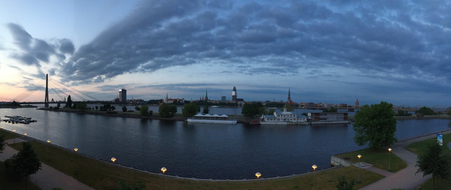
View from my brother’s balcony at 11:30pm.
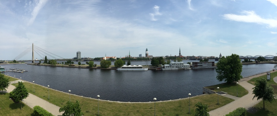
View the next morning.
This post covers Saturday, June 13 to Tuesday, June 30, 2015 (18 days). The beginning will include an overview.
During my 18 days in the Baltic Countries of Estonia, Latvia, and Lithuania, I spend the majority of my time in each of the capitals, taking three-day excursions to each of Tallinn, Estonia and Vilnius, Lithuania. I travel by bus to each of these cities and the buses are surprisingly nice with free Wi-Fi, that was reasonably fast, and an espresso machine that you can use as much as you wish.
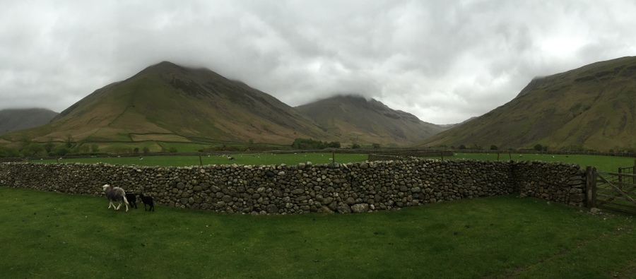
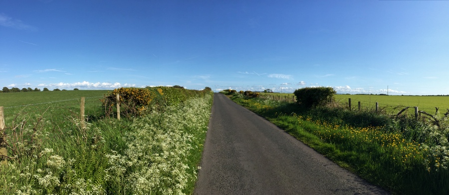
For the summer solstice, we spend two nights in the countryside near Sigulda, located about 40 miles (65 km) northeast of Riga. The summer solstice festival here is huge! It is two days, the day with the shortest night followed by the longest day and they are called Līgo and Jāņi. Although the shortest night is usually on June 21 or 22, the public holidays are always on June 23 and 24.
In general, there are parks and public spaces throughout all of the cities and this stands out to me more than it has in most other cities where I have been. Everywhere is very clean and nice. Costs, depending on the item, are between 30-50% less than the UK: good on the budget!
The remainder of this post has four sections: 1) Tallinn, 2) Vilnius, 3) Riga, and 4) the summer solstice. My time spent in Riga was spread out but I have included it all in one section.
Tallinn, Estonia
In Tallinn, Estonia I am at 59.44 degrees north, which still is not as far north as where I started my cycling in the Shetland Islands of Scotland. When I arrive in Tallinn, I mean to go to a pizza restaurant, but end up at what seems to be a traditional Estonian restaurant. None of the staff speak English, and the hardest item to order was a glass of water. Another customer had to translate for me.
I enter the old town area through one of the original gates where the towers still stand. For the rest of the day I just walk around town looking at the very old buildings. The town is beautiful and I love it already.
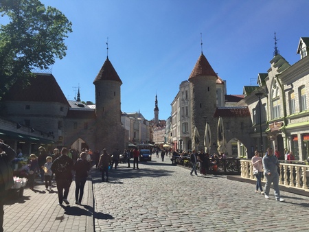
The towers that remain from one of the gates to the city.
I stand in the large public square surrounded by restaurants with open-air seating. I have no idea what any of them serve, or what ethnicity they are, except for Mad Murphy's Irish Pub. I tend to go with local cuisine when I travel but I don't really want to go and ask, "Is this local cuisine?" So I go for it and just pick one.
I start off my second day by seeing Alexander Nevsky Cathedral, just walking around it on the outside. Then I go to St. Mary's Cathedral and take the 140 steps in a narrow spiral staircase to reach the bell tower, which has three massive bells. St. Mary’s Cathedral was in existence in 1219 when Tallinn was invaded.
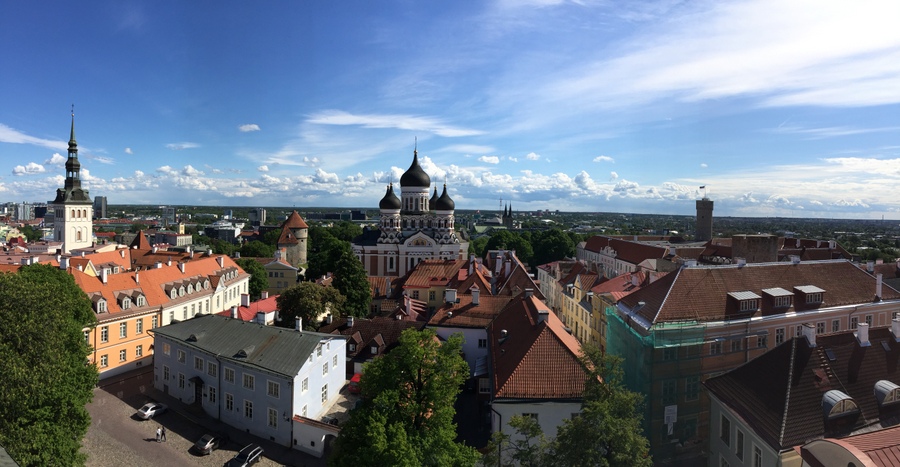
View from the bell tower of St. Mary's Cathedral looking south towards Alexander Nevsky Cathedral.
On my third day, I go to the Niguliste Museum located in St Nicholas’ Church, with one of the most interesting features being that in areas the floor are the very tombstones of people buried there. St Nicholas’ Church was originally built in the early 1200s. It was destroyed in World War II but has now been rebuilt.
In the morning of the last day, I go to Town Hall and see the gallery of art. There are paintings that are 400 years old with realistic looking fruit, and I might admit that it was some art that impressed.
Photo Gallery – Tallinn, Estonia
Vilnius, Lithuania
I arrive into town in the evening and at the bus station buy a kebab wrap to go before walking through the old town to where I am staying. The walking route includes a road that goes right through a building.
I spend the evening in a small square where a musician is playing and has gathered quite the crowd of people sitting around the square.
In the morning of my second day, I switch accommodation because where I had booked was not very good. The new place I am staying is in a building that was originally part of a monastery built in the 15th century and it is safe to say that this is the oldest building I have ever stayed in. The building has settled a bit over the years (hundreds of them), so the floors are slightly unlevel in areas, but I like the character. From my window I have a view of St. Anne's church.
I walk through the Bernadine Park and its gardens, which is bordered by the Vilnia River that meanders through the city.

Bernadine Park.
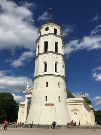
From there I go through another park and into Cathedral Square where there is Vilnius Cathedral and the belfry (bell tower) that stands separate from the cathedral. The original cathedral was built starting in 1251, with the current cathedral built between 1779-1783. The original year of construction of the belfry is unknown, although it is known that it had repairs in 1522.
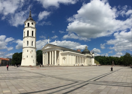
Cathedral Square.
The cathedral is magnificent inside, in one of the side chapels I spend 10 minutes just sitting, continuously finding more details in the carvings, painting, and other artwork. And I could easily spend more time appreciating this single room.
To go to the top of the belfry, I first go up a set of original stone stairs that are within the wall of the tower and curve around the tower as I ascend.
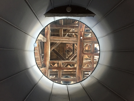
From a lower level, looking up through a glass section of the ceiling to the internal wood structure above.
I go up another set of stone stairs within the tower wall until I come to some modern metal stairs that then lead to original wooden stairs, which have modern handrails now added for safety. There are five sets of original wooden stairs with modern platforms at each level.
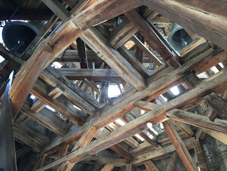
The original wooden structure in the belfry.
The original wooden structure in the belfry.
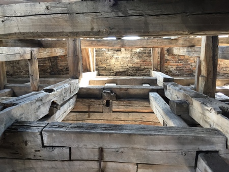
The original wooden structure in the belfry.

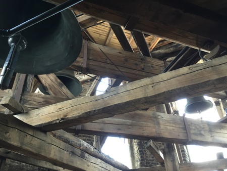
One of many bells in the tower.

The original wooden stairs going up and up.

One of the bells at the highest level.
At 4:00pm I am in the belfry when one of the bells ring. Then at 4:15pm another bell chimes for the quarter hour. I am 10 feet (3 meters) away and it scares the crap out of me!
The belfry.
The belfry with its very old wooden structure and bells is definitely one of the coolest towers I have ever been in.
On Castle Hill, there is a tower remaining that now contains a museum that includes armor from the 14th, 16th, 17th, and 18th centuries (I’m not sure whey there was none from the 15th century!).
View from the top of the tower on Castle Hill.
I walk down from Castle Hill to the Vilnia River and walk alongside it, on the side opposite the gardens. I see that the largest fountain in the park is flowing and spraying to music. From the river I go up to Three Crosses Hill where there is the monument of the same name. From there I go nearby to Stalo Hill (Table Hill).
The next day I am at the National Museum. There is a krater (large vase used for wine and water) from Italy from the 4th century BC, flint tools and stone axe heads from the 2nd millennium BC, silver bars used for currency from the 13th century, a crossbow and arrow tips from the 14th century, and a sleigh from the mid 18th century.
The Palace of the Grand Dukes of Lithuania National Museum was incredible. In the basement of the current palace are the ruins of the original palace, which was built upon ruins of the original castle. The ruins at this level are primarily of the cellars. The columns and structure of the existing building are designed around the ruins, it is all quite beautiful how it fits together. From what they found through excavation, they know the original castle was three stories. Amongst layers of ash are three layers of different style floor tiles that would have been from each story. They believe that part of the building collapsed and burned due to an explosion. The castle palace had 'running' water brought in from the river through wooden pipes and there was also a sewer line built of larger wooden pipes, which all seems quite advanced for the 12th century.

In the Palace of the Grand Dukes of Lithuania National Museum.
The upper floors of the museum have excavated artifacts, medieval armor and weapons, furniture, and extremely large hanging tapestries. From upstairs, the museum continues and leads you back downstairs to the level of the cellars, but the area is not connected to the beginning of the museum. The base of the cellars here are original and then the entirety has been rebuilt with a continuous arched ceiling starting at the floor, creating tunnel-shaped cellars, just like the originals. In these cellars are the royal jewels including the crowns.
At the Museum of Church Heritage there are gold and silver pieces that ranger between 400 to 700 years old, along with articles of clothing over 200 years old.
I return to Vilnius Cathedral for a tour of the crypt where excavations were done 30 years ago to discover the history of the reconstructions of the cathedral. It was rebuilt many times and the low elevation prompted it to erosion. The current cathedral is 10 feet (3 meters) higher than the original and there are many layers of floors that were discovered
At the end of 18th century the crypt was sealed when the current cathedral was built, enclosing the remains of 350 people. In 1931 the area around the cathedral flooded. It took some time for the area to drain and when it did, the cathedral walls started to crack due to ground settling. Later when the crypt was ‘rediscovered,’ what was found was layers of bones amongst rotted coffins. The coffins had floated, moved about, and rotted during an unknown number of floods. There is an area dug out that shows the different layers indicating more than one flood within the crypt. Of the 350 people’s remains, only three could positively be identified. That is because of what managed to still be with them to identify them as kings and queens. They are now in new coffins in the crypt with their crowns on top.
A sarcophagus was made for the body of a duke that died 500 years prior, but they never found his remains upon excavation. Documents record him being buried here, so maybe he is still in a hidden area of the crypt, or was buried elsewhere to hide him, or his royal items were stolen by tomb raiders so he was not able to be identified and he is now reburied in the common area with the remains of all the others.
Coffins have again been placed in the crypt in modern times, but the last was in 1991, but then later moved elsewhere.
I have a pickled cucumber soup as part of my dinner, just to try it and see what it is like because it is not normally the type of item I would order. It was about what you would expect, but it was good and I liked it, although it doesn't have the potential of becoming a favorite.
The day I leave is Sunday so I attend mass at St Anne’s church and then head to the bus station for an 11:15am departure.
Photo Gallery – Vilnius, Lithuania
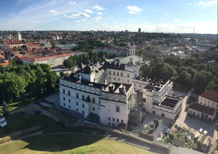
Riga, Latvia
We walk by the House of Blackheads, which was originally built in the early 1300s by a guild of merchants called the Brotherhood of Blackheads. The building was destroyed in a bombing by the Germans in 1941 and then the remains were demolished by the Soviets in 1948. The current building was reconstructed between 1995 and 1999 and is currently the office to the President of Latvia.
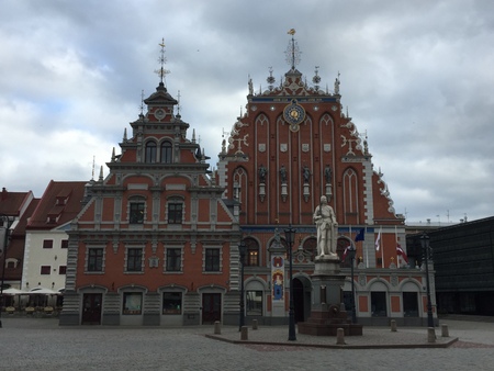
House of Blackheads.
I learn at the grocery store that you don't hand your money directly to the cashier, you set it on the counter, specifically on a tray meant for it. And then they put your change there for you to pick up, rather than handing it directly to you. This is the first I have seen this while traveling.
I go and see the Victory Memorial to Soviet Army, which was erected in 1985 to commemorate the Soviet Army's victory over Nazi Germany in World War II. It consists of an obelisk that is 79 meters (259 feet) tall and two groups of sculptures. It is not only interesting to me that there is a Soviet memorial here considering the country’s whole history, but it is in fact controversial amongst those who live here.
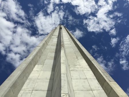
Up close at the obelisk of the Victory Memorial to Soviet Army.
One day I try a garlic beer, which I strongly disrecommend, even if you think you ‘love’ garlic.
Another day we go to lunch at a restaurant owned by man from Mercer Island, Washington. His grandparents are from Latvia and he now lives here. One of the beers we drink, which is brewed here, contains hops from Washington.
EuroPride is hosted in Riga for 2015. With free tickets we go to the concert that was part of the larger event. It was mostly like any other concert. My thoughts on sharing my thoughts about homosexuality: this is a travel narrative.
I was fortunate to be able to take a tour of the U.S. Embassy in Riga, which has a relatively new location in the city, having been completed in 2011. There is a lot of art in the embassy, both from local and U.S. artists. The most interesting thing I learn is that the presence of marines at embassies has been historically to ensure that classified information stay protected. Their job was internal to the embassy and about the security of information, not the protection of personnel. So what is portrayed in most films has been inaccurate. It has not been until recent years that marines’ responsibilities have expanded to outside of the embassy.
I visit St Peter's Church, which is first mentioned in records in 1209. I go up in the high steeple and have amazing views of the city.
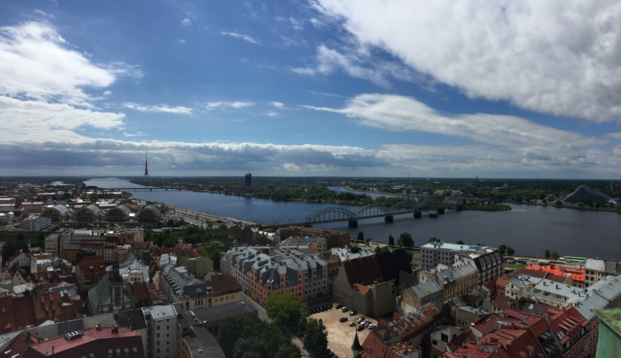
Looking southwest from the steeple of St Peter’s Church.

Looking northwest from the steeple of St Peter’s Church.
Riga is hosting the 8th Nordic and Baltic Choral Festival at Mežaparks, located 5 miles (8 km) north of the city center, so I attend with some of my brother’s friends. The festival started in 1995, then also being hosted in Riga. From 8 countries there are 202 choirs for a total of 6,400 singers at the final event that brings the festival to a close. As the event begins, the singers from each country enter to their own song and choreographed movement. I wouldn’t ordinarily go out of my way to see a choir, but it was really good. It was better than good: it was great.
My brother and I go to an open-air market that has a large portion of the vendors inside four large hangars that originally held zeppelins.
The Museum of the History of Riga and Navigation is very nice. There are dozens of different units for weights and measures dating back to the 14th century, which I realize wouldn’t be interesting to most, but I thought it was all pretty incredible, and that all those units of the past changed and none of them are what we use now. In the 16th to 17th centuries, money forgers had their hands cut off. There is a real hand that had been cut off of a money forger on display in a case. I was not expecting that.
Līgo and Jāņi (summer solstice holidays)
In the countryside near Sigulda.
Just after 9:30pm, a group of us leave from where we are staying in the countryside. On foot. One leads the way and the rest of us follow. After following a path along the edge of a field, we enter into the woods.

On our way to where we are going.
Only one of us knows the way to where we are going. We begin to hear music. It becomes louder as we continue and soon we can see lights. We are soon merging with other people and start heading up steep, wooden staircases built into the hillside. Up we go until we reach the ruins of a castle.
There is a band playing, people dancing, a bonfire burning, and lights from the stage shining out onto the trees within the castle grounds. The bonfire is built to burn from the top down and sized so that it will burn low enough to jump over by the time the sun starts to rise. We’re not supposed to go to sleep until the sun rises, that’s part of celebrating the solstice here.
But the bonfire isn’t going to burn low enough to jump over by the time the sun rises. It is raining. Pouring. Down. Rain. Most people are soaked. People dancing are slipping on the wet boards of the dance area. What should have been an event for thousands only has a few hundred. The bonfire was built to burn at a certain pace when not in the pouring down rain. Not all happens as it is meant to be!
We depart the castle. Trekking back the hour or so to where we are staying. Trekking in the pouring down rain. There is also supposed to be naked running through fields as the sun comes up, but that isn’t looking so likely to happen by anyone this year.
The rain lets up. Back at the place we are staying, we free ourselves from wet clothes. Three of us head outside. It’s 4:00am. We jump in the nearby pond and have a short swim. The cloud-covered skies challenge the fact of the sun rising. We briefly sit in the sauna. It’s past 5:00am, the sun has risen, and it starts raining again, heavy, as I fall asleep.