The Ben Towne Center for Childhood Cancer Research has worked with children from five countries and the progress is being applied to adult cancers as well!
People say I tell great stories, now this is the story I am choosing to tell. In the posts covering my cycling journey, I will include information provided by Ben Towne Foundation (BTF), including some great videos, so we can learn the realities of childhood cancer and the progress happening through BTF. By the end, you will have learned much to see how important the current research is to changing the reality of cancer for children. This story is more important than mine, so please take the time to read these parts and consider being a part of the change!
Did you know: Cancer is the leading cause of death by disease among children in the United States.
Jeff and Carin Towne started Ben Towne Pediatric Cancer Research Foundation in memory of their oldest son Ben, a fiercely determined, passionate and loving boy, who died of neuroblastoma at the age of three. Their experience is not unique. Through this video you will meet several other families who have also lost children to cancer:
Ben Towne Foundation's mission is to change the way childhood cancers are treated and cured. To that end, BTF partners exclusively with the Ben Towne Center for Childhood Cancer Research at Seattle Children's Research Institute, where 100% of contributions are invested.
Friends, together we can be a part of the change, so let’s make it happen ‘sooner than later.’
Please consider donating on the Fundraising Page. Thank you to those who have already donated!
Sunday, May 10, 2015
On the Island of Yell, at 4:40am, it is already quite bright out. I know this because it woke me up this morning. After breakfast, at 9:16am I leave on my bike. The weather is so nice, better than I would have expected from what I have heard, and so I start off in just my cycling shorts and a short sleeve cycling jersey. At 10:00am, after cycling 6.4 miles (10.3 km) south, I arrive at the ferry terminal, having cycled a pace of 8.73 mph (14.05 km/h).
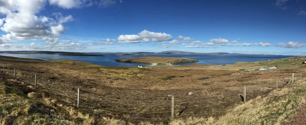
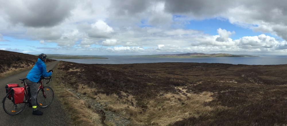
A view from my morning ride to the ferry terminal on the southern side of the Island of Unst.
At 10:30am the ferry departs for Mainland Shetland.

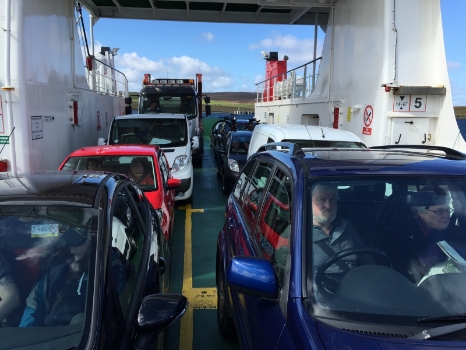
On the ferry crossing over from the Island of Yell to Mainland Shetland.
Once across and after finishing the coffee I purchased on the ferry, I depart the ferry terminal at 10:54am. I arrive at Frankie’s Fish n Chips in Brae after cycling 9.8 miles (15.8 km) south at a pace of 8.28 mph (13.33 km/h). This is the most northerly fish n chips in the UK.
As I sit in the restaurant after finishing, still having a few chips periodically, I reflect on how amazing it is that I have the opportunity to being doing this when I am young and able. It feels good.
I'm cycling slow, intentionally because I can't wear myself out when I have more cycling ahead. I coast on the downhill, to take a break, whereas at home I would change to the high gear and go as fast as I can. As I sit thinking, I envision that I'm going to destroy the miles in the days ahead, every last one of them.
I leave lunch just after 1:00pm and minutes later I have to make a stop to add some layers as during lunch the temperature dropped. The shorts and short sleeve are no longer going to do and I put on a long sleeve and my beloved leggings.
Not too long after that, I have to make another stop to put on my windbreaker and gloves.
I am heading downhill when it starts to become quite windy and it makes it so I can no longer coast. This day’s weather sure changed fast and now with the wind against me, I am pedaling downhill on what I could otherwise coast! The winds have a speed of around 20 mph (32 km/h) most of the time, sometimes a little heavier. When the wind speed changes, I clearly notice it as I slow down while I am pedaling downhill!

Lovely little village or not, I’m still pedaling downhill because of the wind.
The winds are canceling out the gravity that I want to take me downhill. When I stop pedaling, the winds nearly bring me to a stop. The only reason they don’t is because I start pedaling so I do not fall over. Then there is a hill I have to go up! Panniers. Hill. Wind. Not an easy climb!
Then there is more into-the-wind-downhill pedaling and no-coast hills. Wind has become my anti-gravity, but I want nothing to do with it!
It becomes colder. I stop to put on my waterproof shoe covers to help stop the wind from chilling my feet. And I put on the waterproof pants too.
Less than 20 minutes later, it starts to rain. As I am coming to a stop, I have my left shoe unclipped but resting on the pedal. I go to put my left shoe down to the ground and it clips back into the pedal. With my motion barely moving forward, yet my body already leaning towards the left, I fall straight over with both shoes clipped in. Now with the weight of the panniers helping hold my bike down with my leg underneath, I have a nice task to unclip both feet. I manage.
Now that I’m upright, I take off my windbreaker and lightweight gloves and trade them for my waterproof shell jacket and thick waterproof gloves. Onward!
The wind hasn’t stopped, it is raining, and the downhill pedaling keeps coming: this isn't the experience I started with this morning in the beautiful sunshine!
I take a break to eat in the pouring rain, because there is no option to get out of it. After I leave my stop, I see a man running in this awful weather and I think to myself, ‘what an idiot.’
Now there is a massive hill. It is the hill I have heard about. It is raining. It is windy. I can't do this. But I don't walk hills. I can't remember ever having taken a break on a hill. I generally love the challenge of hills. I take three or four stops on this hill, each time resting for just a few minutes and then continuing. I shall not walk!
Cycling up hills into the wind while it rains. All smiles here.
After arriving at the top, I do get some free miles coasting down on the other side.
Then there is another hill! No one mentioned a series of hills. I take even more breaks on this, each just being a few minutes, enough so that my muscles don't start to burn. This is a different game plan, this isn't simply about today, but the days ahead. High cadence, no burn.
Finally, at 4:45pm, I arrive at Mark’s home in Lerwick, since lunch having cycled 22.8 miles (36.7 km) at a pace of 6.13 mph (9.97 km/h).
Photo Gallery – Shetland Islands: Cycling Days 1 & 2 (new photos added)
For dinner Mark, Mairi, and I have scallops and then go to two pubs.
Daily cycling stats:
Distance: 39.0 miles (62.8 km)
Moving average: 6.92 mph (11.14 km/h)
Monday, May 11, 2015
I make croissant breakfast sandwiches for the three of us. This comes with great skepticism from the Scots as neither Mark or Mairi had ever heard of such a thing!
At about 4:10pm it starts to pour rain, which is not encouraging to Mairi and I. At 4:20pm we leave Mark’s home on our bicycles and after 1.3 miles (2.1 km) we are at the ferry terminal and soaked. What a great farewell from Lerwick!
At 5:30pm, we depart on the ferry MV Hjaltland. The ferry heads south, 103 nautical miles south, and arrives into Kirkwall in the Orkney Islands at 11:00pm.
From the ferry terminal, we cycle 1.6 miles (2.6 km) to the hostel we have booked for the night. The hostel is very nice and in the shared kitchen we sit down and review options for the upcoming days and make some decisions.
Daily cycling stats:
Distance: 2.9 miles (4.7 km)
Moving average: (not tracked)
Tuesday, May 12, 2015
After buying our food for the day at a grocery store, we cycle 6.8 miles (10.9 km) east and arrive at Sheila Fleet Jewelry. This is a famous jewelry maker and Mother’s Day in the U.S. was a few days ago, so I buy some earrings and have the shop mail them to my mom.
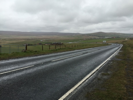
Cycling route heading east from Kirkwall.
From the jewelry shop, we head south. We come to a road across a narrow causeway that is our route. On either side is the ocean, with waves crashing into the rocks forming the causeway. Before we cross, we can see the ocean spray occasionally come up onto the roadway. When we cross we feel a bit of the spray.
Shortly after crossing the causeway, at 2:10pm we arrive at the Italian Chapel, having cycled 7.4 miles (11.9 km) from the jewelry shop. The Italian Chapel has its name from the men who built it starting in 1943, while prisoners on Orkney, at what was then Camp 60. Within the prison camp they built it and today it is all that remains of that camp.

Interior of the Italian Chapel on Orkney.
After a stop at a nearby wine shop, and eating lunch outside in the mild wind, we head north. We cross back over the causeway. There is more of the water from the waves coming onto the roadway, much more. As I cross, a wave hits me, I can’t see at all for some moments, and I taste the saltwater. Mairi, behind me, experienced some wave action too. You aren’t supposed to be coated in saltwater from the ocean while cycling!
At 4:30pm we arrive back into Kirkwall at St. Magnus Cathedral, having cycled 7.8 miles (12.6 km) from the Italian Chapel.

Cycling route heading north from the Italian Chapel.
St. Magnus Cathedral is the most northerly cathedral in the UK and its construction began in 1137.

Interior of St. Magnus Cathedral in Lerwick.
Not far from the cathedral, we have burgers at a restaurant. After enjoying a nice break, we leave dinner at 6:50pm and head southwest in the rain.
The rain does not stop during the 10.4 miles (16.7 km) we cycle to the B&B in Houton where we arrive at 8:35pm. It is directly adjacent to the ferry terminal, the access literally crossing through the waiting line area.
Photo Gallery – East Mainland Orkney: Cycling Day 3
Daily cycling stats:
Distance: 32.4 miles (52.1 km)
Moving average: 6.44 mph (10.36 km/h)
Wednesday, May 13, 2015
We wake up at 6:45am, have breakfast, and depart on a ferry at 8:00am heading south.
After the ferry makes a stop on the Island of Cava to drop off some workers in the oil industry, it arrives at 9:00am in Lyness on the Island of Hoy.
Right across from the ferry terminal is the Scapa Flow Visitor Centre and Museum, which is not open. However, there is lots to see outside and there is a hangar style building with a lot of old boats that is open. We see canons, anti-torpedo netting that was used under water to protect ships, a massive boat shaft and prop recovered from the bottom of the ocean, a lifeboat designed to be dropped from the air, a boat that was a mobile bank, and many other boats.

Anti-torpedo netting that had been installed in Scapa Flow in 1938.
We leave the museum at 9:30am and after cycling west just 0.9 miles (1.4 km) arrive at the Lyness Royal Navy Cemetery.
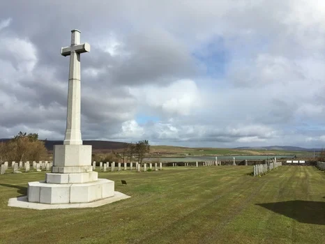
Lyness Royal Navy Cemetery on the Island of Hoy.
We leave the cemetery just after 10:00am and cycle west 9.1 miles (14.6 km) to a café where we have lunch. There is a fire going, so I take off my socks and shoes to dry them and warm them up.
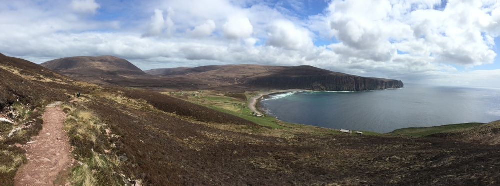
Taking in the beautiful cycling route on the Island of Hoy.
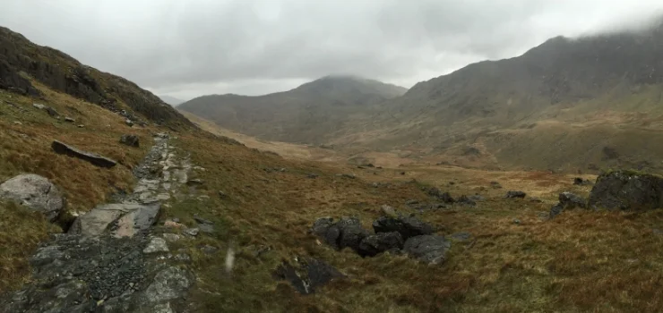
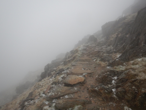
From the café, we cycle southwest 5.5 miles (8.9 km) and arrive at a trailhead near Rackwick. We set off at 1:51pm and do have some time constraints. At a quick pace, we head up the trail, enjoying the sun that is out, and the views, and taking too many stops to take photos of the beautiful views.
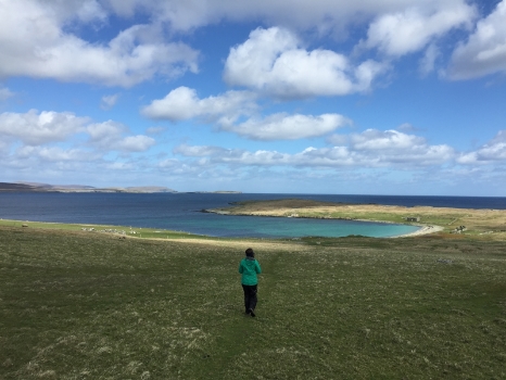
Looking down on Rackwick Bay and the township of the same name.

The hiking trail.
At 2:42pm, we reach our destination, the Old Man of Hoy, a red stone sea stack that is 449 feet (137 meters) tall. It has been created over, well, basically forever.

Old Man of Hoy.

The cliffs along the coast near Old Man of Hoy.
We made really good time on the ascent, so enjoyed some time at the top where we ate some food. We leave the old man behind, and head down at 3:10pm. Back at our bikes, I have to change back into my cycling shoes and pack my lightweight backpack and valuables, which I took with, back into the panniers. Mairi went ahead, and at 4:15pm I am on the way too.
I catch up with Mairi. Before arriving at the ferry terminal, we were confused where it was since where we thought it was per our map, we could not see any structure. So we cycled along a small road paralleling the coast and figured we would ask the first person we saw. This ends up being a small boy on a tricycle. He confirms the ferry was indeed where we thought it should be. So we turn around to head back the way from where we came. I challenge the young man to a race. He accepts. For several minutes, we ride along side-by-side. He riding as fast as he can pedal that tricycle, and I matching his pace, acting like I am also riding my hardest.
The ferry terminal ends up being very close to the café we had eaten at earlier, and brought us 5.8 miles (9.3 km) from the trailhead.
This ferry is a passenger only ferry, so did not have a proper place for our bikes. They were loaded into the bow of the boat. It doesn’t matter, whatever takes us and our bikes to where we need to be! From Linksness on the Island of Hoy, we cross over to Stromness on West Mainland Orkney.
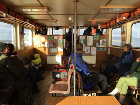
The passenger ferry on which we departed the Island of Hoy.
Tonight we are staying at a place in Stromness that we booked through AirBNB. Neil meets us at the ferry terminal on foot. We walk back to his home that is not far, but the route does include a series of stairs. This isn’t the most exciting part of the day, to carry my bike with panniers up flights of stone stairs in my cycling shoes. His home is located amongst other homes and does not have a driveway to it, why he met us at the ferry terminal since we might have struggled to find it.
We meet Neil’s partner, Jenny, and have a tour of their home. It is a split-level design, having a total of six levels, with a height of about a three-and-a-half story house, which Neil designed! The home is heated from the earth, with a geothermal loop that goes hundreds of feet down to extract heat from underground. Of their three daughters, one is still at home, so they have recently decided to rent the other two rooms. We are in fact their first guests!
After dinner we enjoy some glasses of wine in the living room at the top story, with a view of the water. Later we go out to a pub and have some pints.
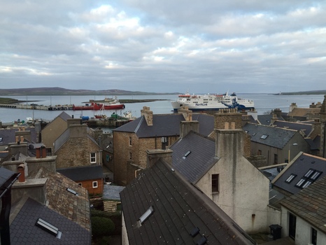
View from the living room story of our host’s home.
Photo Gallery – Island of Hoy: Cycling Day 4
Daily cycling stats:
Distance: 21.3 miles (34.3 km)
Moving average: 5.86 mph (9.43 km/h)
Thursday, May 14, 2015
After visiting a museum in town and buying food for the day, we head northeast. After cycling 6.6 miles (10.6 km), we are at the Standing Stones of Stenness. Put upright 5,000 years ago, this is one of the earliest stone circles in Britain, potentially older than the well-known Stonehenge. The site would have had ceremonial uses and had a hearth in the center for fires.

Some of the Standing Stones of Stenness.
Next up, just 0.9 miles (1.4 km) away, is the Ring of Brodgar, another circle of standing stones in a larger diameter layout. There is one that was shattered by lightning in 1980, just some 4,000 years after it was put up.
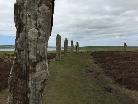
Stones of the Ring of Brodgar.
From there, we cycle west 5.4 miles (8.7 km) to arrive at another site.

Cycling west from the Ring of Brodgar.
Skara Brae is a 5,000 year old farming village, the oldest known village in Europe. Besides farming, evidence shows the community also fished and hunted. A winter storm in 1850 ripped grass and sand away from a high dune, uncovering the site of ruins. From carbon dating, it is known that it was inhabited for a period of 600 years.
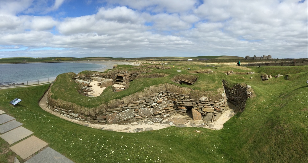
Ruins of the 5,000 year old village of Skara Brae.
As we depart from Skara Brae just after 5:00pm, it is sunny and there is no wind. The wind turbines aren't moving and that is great for us. We cycle north, parallel to the coast but a ways from it, but with views of it at times. We arrive at our hotel in Barony after cycling 7.3 miles (11.2 km).

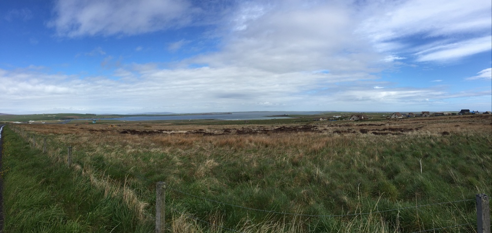
Cycling north between Skara Brae and our hotel.
The hotel overlooks a lake by the name Loch of Boardhouse. Today is the first day of cycling that we are not laying out clothing to dry!
After dinner, at about 9:30pm, Mairi and I leave the hotel on our bikes. We cycle 1.8 miles (2.9 km) to the water’s edge. We are here now because of the time of the tide, it is going out. Across the water is the small island called Brough of Birsay. At 9:45pm we are walking across the rocks and concrete pathway revealed at low tide. It is like a secret passageway, hidden most of the day, and also limits ones visit to the island if they don’t want to be wet on the return. Out on the island are the ruins of buildings from a Norse settlement, the buildings from different periods between the 9th to 12th centuries. There are also puffins, rabbits, and an operational lighthouse.

The path at low tide across to Brough of Birsay.
Photo Gallery – West Mainland Orkney: Cycling Day 5
Daily cycling stats:
Distance: 20.2 miles (32.5 km)
Moving average: 6.97 mph (11.21 km/h)
Friday, May 15, 2015
After breakfast, we start cycling southeast, then northeast, cycling 12.1 miles (19.5 km) before ending up at Broch of Gurness at 11:20am.

Cyling route from the hotel to Broch of Gurness.
The Broch of Gurness is the central building in the ruins of a 2,000 year old farming village. It was discovered accidentally in 1929 when an artist was sitting on a stool on top of a mound and one of the stool legs sank into a hole. He then dug and found a staircase.
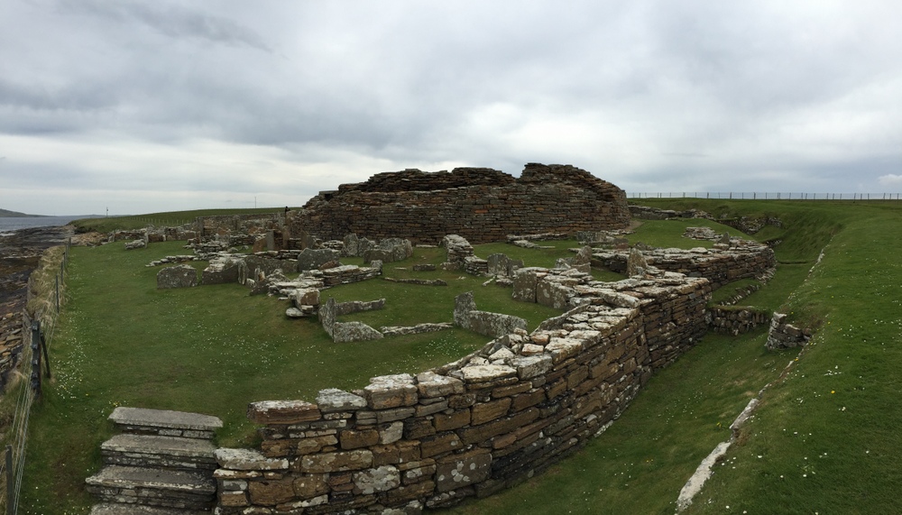
Broch of Gurness.
I rushed through the site in less than half an hour and then was off, heading south in a hurry. This is where my cycling journey parts ways with Mairi’s. After cycling 12.2 miles (19.6 km) south, I arrive at Maeshowe for a booked tour. (Pronounced “mays how.”)
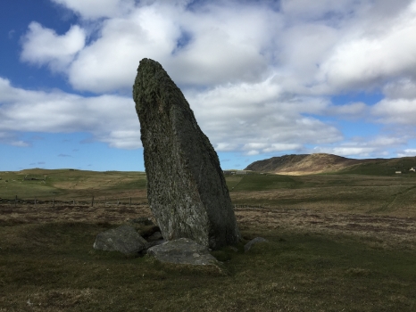
Maeshowe is a building located beneath a mound that is a chambered tomb built 5,000 years ago. It is incredibly well preserved, other than there no longer being any human bones. The long entry corridor, in which you must crouch to pass through, aligns with the space between two peaks across on the Island of Hoy, where we were two days ago. The space between the peaks coincidentally aligns with the setting sun on the winter solstice. On the winter solstice, the setting sun aligns perfectly with the entry. As the sun sets, its light slowly enters the entry and into the tomb until it is at its brightest. For three weeks on either side of the solstice this occurs. There is also a lone standing stone on Orkney that is between here and Hoy that aligns perfectly with the setting sun on the winter solstice. The standing stone is in the middle of what is now a farmer’s field. In the 12th century, Vikings broke into Maeshowe through the roof during a storm. They left 24 sets of carvings, and how their time there is exactly known.
At 3:00pm I leave Maeshowe heading south. The weather has worsened from earlier today and my 3.1 layering system now reaches 4 when I add my rain jacket on top of my windbreaker. The rain doesn’t stay, so I stop and take off my rain jacket. Minutes after leaving from that stop, it starts raining, so I stop again. After cycling 5.6 miles (9.0 km) south, I arrive at the ferry terminal in Stromness at 3:35pm.

Cycling south from Maeshowe to the ferry terminal in Stromness.
Despite the generally awful weather, I am loving the cycling and carrying everything with me on my bike.
At 4:45pm I depart on the MV Hamnavoe heading south. Farewell to you Orkney!!
This day to be continued.
Photo Gallery – West Mainland Orkney: Cycling Day 6
Daily cycling stats:
Distance: 29.9 miles (48.1 km)
Moving average: 8.08 mph (13.01 km/h)
Accumulative cycling stats:
Distance: 170.0 miles (268.9 km)
Moving average: 7.01 mph (11.08 km/h)
Please consider donating to Ben Towne Foundation on the Fundraising Page. Thank you to those who have already donated!

Map of cycling route on the Shetland and Orkney Islands:

Maps for all countries are now up on the Map page.
“Feeling my way through the darkness, guided by a beating heart, I can't tell where the journey will end, but I know where to start. They tell me I'm too young to understand, they say I'm caught up in a dream. … So wake me up when it's all over, when I'm wiser and I'm older.”
Lyrics from the song Wake Me Up by Avicii.